 Version
1.1.1
Version
1.1.1
 Package Name
com.odottraffic.odotlocationfinder
Package Name
com.odottraffic.odotlocationfinder
 Category
Travel
Category
Travel
 Size
1.91MB
Size
1.91MB
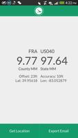
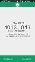
Find your current location on Ohio roads using the ODOT classification system
Find your current location on the Ohio road network using the ODOT classification system: County, Route, and Section (county log point or state mile marker).
*Please note this only works in Ohio*
The location information can be exported via email.
This app was first implemented by ODOT District 11 as a website and developed into a mobile app by the ODOT Office of Traffic in parternship with ODOT IT.


 Download APK(1.91MB)